
114 traditions in american design: the south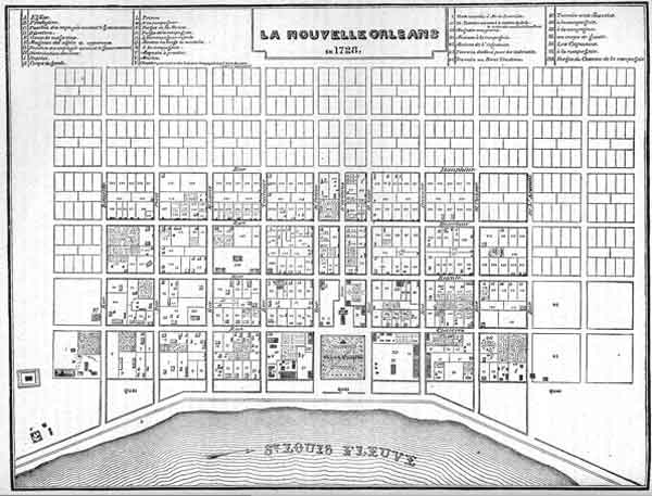
Plan of New
Orleans, 1728. A classic Baroque grid, given some distinction by the
square on the riverfront (the Place d'Armes, now Jackson Square) and
the siting of the projected cathedral and public buildings on its edge.
The South's first settlement, Jamestown, Virginia, seems to have been triangular in shape, a fitting introduction to a career in design filled with variety and fantasy beyond the New Englanders' dreams. Of the first Southern towns to attain any size, New Orleans was a strict grid with a single square in it. Charleston started out the same, but did not stay that way for long. Almost from the beginning, landowners laid out new streets however they pleased, while such tight-fisted governors as the Duke of Bedford began to encroach on the square, which disappeared entirely by 1788. By this time, however, Charleston had grown up to a wealthy and cosmopolitan town, and it was embellishing itself with fine buildings, parks and even street lighting. Here, design followed the informal manner of the New Englanders, and the people of Charleston polished it to a level of sophistication that made it one of America's most gracious cities. The new landmarks, St. Philip's and St. Michael's and the Exchange, were all sited at the focal points of important streets; St Philip's incorporated another design trick of the day; its portico, projecting into the street, intersected the views down the side streets in the same clever way of its near-contemporary, St-Martin's-in-the-Fields in London. Elsewhere in the South, gentleman proprietors and royal governors were producing elaborate plans that would have been thought perfectly up-to-date anywhere in Europe. The jewel of formal design in America is Maryland's capital Annapolis. We owe it to Francis Nicholson, a man widely traveled and experienced in military and administrative affairs; he knew Christopher Wren from his days in London. Nicholson was Governor of Maryland in 1694, at the time when Annapolis was being considered as a replacement for St Mary's, the old Catholic capital that never thrived. The remarkable design he commissioned contains everything that was up-to-date in the town design of Georgian England. There are two great circles, probably intended for residential 'crescent' terraces, grand axes, and even a space marked 'Bloomsbury Square' (unfortunately never realized). Everything a city might need was foreseen: schools, quays, a market square. 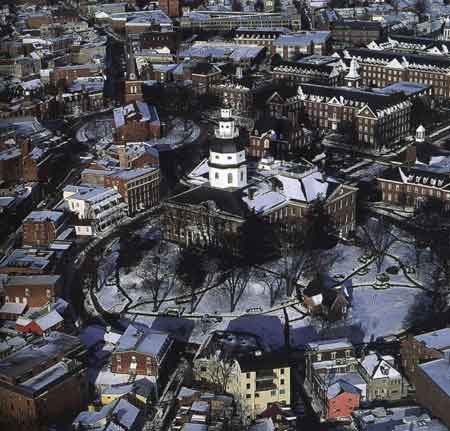
For all that, the greatest amenity was the elegant plan itself. After Nicholson was no longer around to explain, Marylanders lost all conception of just how artful their capital's layout really was. It astonished local archaeologists in 1990 when their careful measurements turned up perspectivist tricks in Annapolis' streets that we would expect more from the Athenian acropolis or the Great Pyramids. They discovered that the street lines along the major boulevards leading towards the Capitol building are not parallel; they bend out slightly as they approach the circle—imperceptible, but making the buildings they frame seem closer and more imposing. And the circles themselves aren't really circular, but slightly elliptical, causing them to appear perfect circles from major lines of sight. In 1698 this able administrator was transferred to the governorship of Virginia, and he got a second chance to plan a capital. Apparently the Virginians didn't like Nicholson's first effort, which may have been as recherché as that of Annapolis. It seems to have had a W and M (for King William and Queen Mary) built into the street plan. The second, successful design created a grand axis, a long, 99 ft-wide avenue at the top of a ridge, with the College on one end and the Capitol on the other. In the center was a market square with room for a courthouse and church, while a small secondary axis near the center led to the governor's mansion. It was a handsome plan, and a lesson for all small towns-one that demonstrates how easy it is to create a sense of place from the simplest of design interventions. 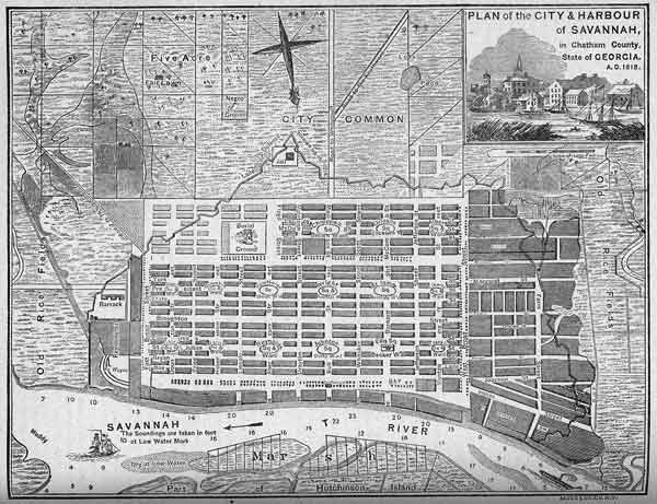
An equally remarkable and successful example of the South's formal planning belongs to Savannah. James Oglethorpe, soldier, statesman, prison reformer and founder of Georgia, presented an idealistic scheme for the resettlement of England's imprisoned debtors that won him a royal charter in 1732. The excellent Mr. Oglethorpe's care for Savannah gave each colonist not only a house lot in the new town, but five acres for a garden on the outskirts, and additional farmland further out-50 acres in all. But beyond his philanthropy, Oglethorpe is rightfully remembered as one of the great American planners. He was familiar with Philadelphia, and probably also with the grand schemes for rebuilding London after the Great Fire. His Savannah was to be a unique, cellular city, based on the repeating unit of twelve blocks forming a square, with a residential park at the center. Two sides of each park square were reserved for important buildings: a pastor's house, a storehouse, church or school. In Savannah, the 'principle of the second man' came up trumps. Oglethorpe's plan was so simple and amenable that the townspeople carried it forward for over a century. The original settlement was a block of four of his square units; new ones grew up alongside like crystals, and by 1856 there were 24 of them, each a city ward in itself. Though alike in plan, time and circumstance had varied them in character. Some squares were wealthy, some poor; some plain, others lined with ornate townhouses. But every one had its central garden. Each was a world of its own, a cohesive neighborhood that residents loved and defended. Importantly, the 'second men' had found a principle for keeping traffic away from the cellular units. Main thoroughfares were run along their edges, leaving them as peaceful islands in between. Savannah, like Charleston and Annapolis, passed through the disasters of the twentieth century with its inner-city neighborhoods in far better shape than most comparable cities. Quality endures. A few other Georgia towns tried to follow the Savannah plan: New Ebenezer, which didn't thrive, and later Brunswick (1771). But as urban development fell under the control of land speculators after the Revolution, no others followed. Some towns did try a little to gain some distinction: Jackson, Mississippi laid out a gracious design (1822) with a big common, faced by a Crescent Street and other parks. New Orleans built new residential squares, and in the 1840's perfected one of America's great open spaces, Jackson Square, with the reconstruction of its public buildings and the creation of the famous Pontalba Buildings along the flanking sides. Among the other towns, few indeed chose to follow the lead of Charleston or Annapolis, and even Williamsburg itself was allowed to fall into decrepitude. Perhaps from the beginning, economics and custom had determined the South would be a land poor in towns. Its first, Jamestown, also became the first ghost town, after it was burned by angry farmers in Bacon's Rebellion of 1676. Conditions in the best of times could be primitive indeed. One Maryland surveyor, pressed by the authorities to deliver a town plan in the 18th century, replied 'that for the want of some Large Paper to draw the same on, it is not yet done'. In Virginia especially, with so many landings on the Tidewater rivers, it was easy for planters to ship directly to England, and they resented the Crown's efforts to build up towns by requiring storage and transshipment. If the authorities had won, Southern history would have been quite different. Under the corrosive pressures of American life, the Southern formal tradition withered away just as surely as the informal planning of New England. By 1850, a new town in Alabama would look little different from one in Wisconsin. How did they look? Most were clean and dull and rectilinear, but for many, especially in the South, we might drag in that matchless urban observer Mark Twain, and let him give his report on Arkansas City, Arkansas: 'It was born of a railway-the Little Rock, Mississippi River and Texas Railroad touches the river there. We asked a passenger who belonged there what sort of place it was. 'Well', said he, after considering, and with the air of one who wishes to take time and be accurate, 'it's a hell of a place.' A description which was photographic for exactness. There were several rows and clusters of shabby frame houses, and a supply of mud sufficient to insure the town against a famine in that article for a hundred year; for the overflow had but lately subsided. There were stagnant ponds in the streets, here and there, and a dozen rude scows were scattered about, lying aground wherever they happened to have been when the waters drained off and people could do their visiting and shopping on foot once more.' Unlike their colonial counterparts, the free American city founders cared as little for simple matters of public health as they did for any amenity of design. Before we close the book on the South we must mention the last hurrah of the Southern formal tradition, the great plan for Washington DC. It was the collaboration of a Frenchman, Pierre L'Enfant, and what was then a very enlightened patron, the United States government. Considerable ink has been spilled over the influences behind this plan, but one oft-overlooked fact explains nearly everything. L'Enfant's home town was Versailles, where not only the royal gardens, but the layout of the aristocratic suburb itself would have taught him something every time he took a walk. There was another influence, not that far from the Potomac: Francis Nicholson's Williamsburg. Look at each plan, and you'll see a long axis sited on the seat of government, intersected by a shorter one with an executive mansion as its focus. L'Enfant packed along enough frou-frou from Versailles to decorate every important corner of town. In his grid, carved up with diagonal boulevards, he projected a Grand Avenue east of the Capitol, a square north of the Mall for a non-denominational 'National Church', and five sculptural fountains at strategic spots. There was to be a milestone column behind the Capitol, like the one in ancient Rome's forum. Also an equestrian statue of Washington on the Mall, like those of Bourbon kings in the royal squares of Paris, and even arcaded shopping streets, copying Paris's Palais Royale. It could have been gorgeous. And it has turned out well enough, even though succeeding 'second men' did not always share L'Enfant's vision of a Paris on the Potomac. The ultimate francophile, Thomas Jefferson, had a hard time with the plan. For all his architectural talents, Jefferson seems to have been incapable of seeing or appreciating anything more complex than a simple grid; he did in fact offer a weak and poorly-considered grid plan himself when the capital was first discussed in 1791. But as president, Jefferson put the arm on Congress for money to see L'Enfant's design through, and he devoted his efforts particularly to making a proper boulevard out of the broad muddy stretch of Pennsylvania Avenue. Washington was lucky with the 'second man' for another century, especially when Daniel Burnham came in with his McMillan Plan of 1902, to perfect L'Enfant's concept and weed out some of the damage done to it over the years. L' Enfant's ideas and Burnham's meshed nicely; the combination of the two, captured around the Capitol Mall, remains the symbol for what now became a truly American vision in formal design. 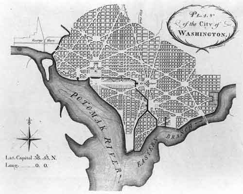
|
|

|
